This mountain, known as the first peak of Chengdu, is 5364 meters above sea level. Because of its historical and cultural background and the status of the virgin peak, it has attracted more and more attention from domestic climbers since 1998. To date, more than a dozen (times) climbers have attempted to climb this mountain. At the same time, due to the technical difficulty of climbing the mountain, a fatal accident in the spring of 2002 greatly increased its popularity.
The main peak of Daxuetang is located at the junction of Chengdu City, Aba Tibetan Autonomous Prefecture and Ya'an. It belongs to the southern end of the Yushan Mountains in the northeast of the Hengduan Mountains. The southeastern corner of the mountain is known as Xiling Snow Mountain in Chengdu. It is famous for its Du Fu poem “Window with Xiling Qianqiu Snow†in the Tang Dynasty. Now it is a famous tourist area in western Chengdu. The northern foot of the mountain belongs to Wolong Nature Reserve in Wenchuan County of Aba Prefecture and is currently the only location for climbing routes.
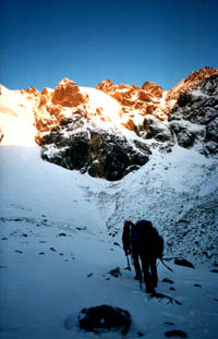
In the early morning of May 2002, Xu Xiaoming and his teammates began the day's climb (right). Because the Big Snow Pond is not stable, and rolling stones are frequently used after sunrise, there will be avalanches after heavy snowfall. Early departure is the best way to avoid these situations.
Climate and terrain:
It is understood that the mountain is stable in winter (before and after the Spring Festival) with less precipitation. In other seasons, there should be more regular good weather, but more precipitation. Avalanche occurs near the climbing route a few days after heavy snowfall. In some locations, rolling stones are frequent. In May, the temperature can reach over 20 degrees when there is no wind on a sunny day. At night it is minus 10 to 20 degrees.
Climbing route:
Currently, there is only one climbing route, which starts from Dengsheng Protection Station of Wolong Nature Reserve on the north side of the peak and follows the valley southbound. It takes about a day and a half to reach the camp at 4,550 meters. On the way, you need to cross the thick jungle and the Du Fu from the ancient glaciers and the Rolling Stones. There are many locations on the way to set up camps. The usual practice is to set up a base camp at 3,300 meters or 4,000 meters and a camp number 1 at 4,550 meters. It is also possible to set up the base camp directly at 4,550 meters.
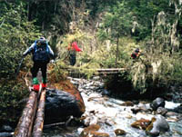
The players are trekking in the jungle (pictured right). This wooden bridge will go through several times on the way to Base Camp.
The 4550 camp is located on the east side of the main peak, where you can see the edge of the snow basin under the main peak, but you can't see the main peak. From here you can see there are two glaciers hanging from the snow basin under the main peak. The main route is from the right side of the glacier. The right edge of the ice rock climbs at the junction. This section will pass through three terrains: a narrow snow lane called the "bowling lane"; a fan-shaped avalanche slot called the "snow funnel"; and a small ice wall of about 70 degrees. The height of the whole course is about 450 meters, and the average slope is 40-45 degrees. Along the way, ice cones, snow cones and rock cones can be used for protection.
After the ice wall, there will be a gradually slower slope, rising about 50-100 meters to reach the northeastern edge of the basin type snow cover at 5150 meters. The snow basin is similar to a circle, slightly tilted to the east, with a diameter of about seven hundred to eighty meters to one kilometer. In addition to the two glacial gaps on the eastern edge, there is a clear edge surrounded by high and low peaks. Perhaps this is the origin of the name "Great Snow Pond".
The main peak is located at the northwest edge of the snow basin. However, because the western and northern edges of the snow basin are all steep and straight, and the rock is more than 100 meters away, the stone is broken and difficult to climb. Relative to the steep, undulating ridges and long ridges on the north side, the best climbing route should be to cross the snow basin to the southeastern edge, and climb north along the eastern edge ridge to the top. Since the route is longer and the route is dominated by steep rocks, it is recommended that the climbing team set up a camp in the snow basin (5150) and prepare rock climbing equipment.
About migrant workers:
Due to the rugged road from the Dengsheng Conservation Station to the 4550 camp, it was not possible to transport the animals. The main assistance for the transportation was to be completed by local migrant workers. Due to the stimulation of several climbing activities in recent years, local migrant workers have had certain experience and scale, but there is still a lack of regulations. Conflicts often occur when coordination with a mountaineering team is not good. It is understood that the local migrant workers are charged 15-20 kg per person, with medium speed, 6-8 hours of travel, and a fee of 30-50 yuan, which is more acceptable. They should also be given the same requirements when the team is required to stay at the camp. remuneration. And migrant workers are not willing to pay for jobs other than transportation, but they can ask them to help them when relations are harmonious. It is not necessary to be responsible for food and accommodation during the night below 3550 meters above sea level.
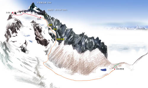
Big Snow Pond climbing road map (click here for details)
In general, the large snow pond is only a common five-kilometer mountain in Sichuan Province. In recent years, climbers throughout the country have made numerous attempts and data collections, laying a good foundation for climbing it. As a mountain that is not far from the urban area and has certain climbing technical requirements, it is bound to attract more climbers to its feet. However, due to the mixed data in the past, the data above 5150 meters is even blank, and the unknown makes it difficult to accurately assess the difficulty. According to the first-hand data obtained during the climb, the difficulty of the course below the snow basin (5050m) is lower than that described in the previous data, and the difficulty of the route above the snow basin is far more than described in previous data and it is difficult to follow the route below the snow basin. At present, none of the teams that have climbed this mountain has the necessary time and necessary equipment for the summit, so the large snow pond may still be a maiden peak. It is hoped that the future climbers will be adequately prepared and expect them to make more perfect conclusions for the big snow pond.
- From "Cowin Adventure"
Mailing Bags/Express Bag
Mailing Bags are specially designed for postal or courier transport, thus it's also called Express Bag or Courier Bag, featured by light, waterproof and integral adhesive strip. Plastic Mailing Bags add a waterproof layer to products and packages sent through the post. We supply a range of strong, durable, high quality, great value mailing bags.
Mailing Bag,Express Bag,Plastic Mailing Bags,Printed Poly Express Bags,Courier Bag
Shifang Packaging Material Co., Ltd. , http://www.simplefine.com.cn